Author: sfleccadmin (Page 11 of 12)

SFLECC Meets with US Fish & Wildlife, NIPSCO, & US Senator Dan Coats

FOR IMMEDIATE RELEASE
MONTICELLO, INDIANA
DATE: August 16, 2016

SFLECC MEETS WITH U.S. FISH & WILDLIFE, NIPSCO AND U.S. SENATOR DAN COATS

During the past weeks, SFLECC has continued its fight, along multiple fronts, to maintain lake levels by eliminating flow requirements imposed again this summer by the U.S. Fish and Wildlife Service (FWS). First, SFLECC has met with more than a dozen officials from both FWS and NIPSCO to address SFLECC’s concerns about the lowering of Lake Freeman. After the meeting, SFLECC Executive Director, Joe Roach commented: “FWS suggested it would consider ‘alternate solutions provided by an independent source’. FWS, however, could not immediately identify any funds that it could use to help develop the independent solution it desires.” Meanwhile, SFLECC has already spent more than $250,000 to prepare and file legal papers and expert reports demonstrating that FWS’s flow requirements are not based on sound science and should be eliminated.

Lakes Level Task Force Chairman, John Koppelmann, who attended the meeting added, “In the past 15 months, the Federal Energy Regulatory Commission (“FERC”), which will determine whether FWS’s flow mandates are made a permanent part of NIPSCO’s license, has received reports from our two expert hydrologists. Those reports demonstrate that maintaining constant lake levels is the best, scientifically-based means of providing the natural rate of flow for the mussels.”
Koppleman continued, “Once our experts’ reports were submitted, FERC’s own staff, including more than a dozen consulting scientists, as well as hydrologists commissioned by the State of Indiana also filed reports unanimously concurring with our experts about maintaining the lake levels. The science is in and we think all of these reports represent the views of ‘independent sources’ that should be adopted by FWS, without the delay and expense of more studies.”

In addition to meeting with FWS and NIPSCO, SFLECC president, Lee Kreul and Monticello Mayor Ken Houston met with U.S. Senator Dan Coats last week and requested assistance in expediting the release of the final environmental report from FERC. FERC released its initial environmental analysis last October and largely concurred with the SFLECC’s position; however, until the final report is released and FERC Commissioners determine what license requirements are appropriate, FWS’s mandate remains in effect. Kreul commented after the meeting, “Senator Coats listened to our plight and promised to make an official inquiry with FERC.”

Finally, SFLECC officers also met a member of U.S. Rep. Todd Rokita’s staff and requested assistance with FWS. “SFLECC is pulling every lever in this complicated battle, even though we don’t control the dams – – NIPSCO does – – and we are largely at the mercy of NIPSCO and FWS’s mandate.” said Kreul. Citing the Endangered Species Act, FWS first ordered increased flow during a drought in 2012 to provide more water for protected mussels below the Oakdale dam. FWS’s mandate went into effect again in 2014 and 2015.

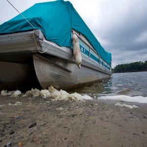
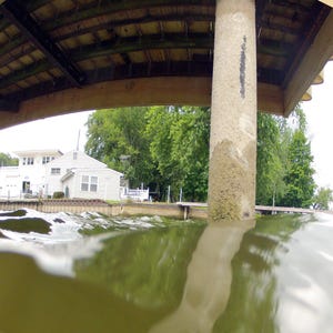
This year, on August 4th, NIPSCO again alerted Lake Freeman residents that “Abnormal Low Flow” conditions existed because flow readings at a gauge at Winamac had dropped below 300 cubic feet per second (cfs). As a result of FWS’s mandate, NIPSCO discharged required flow rates at the Oakdale Dam that caused Lake Freeman’s levels to drop steeply. Despite this past weekend’s rain, as of the morning of Monday, August 15th the level of Lake Freeman was at ten inches below normal as reported on NIPSCO’s website – – while some residents have reported even lower readings. With heavy rainfall later in the day, the Lake was returned to normal levels.

What you can do to help:
SFLECC urges residents to:

-Contact your congressional representatives. Ask them to urge FERC to release its final report and encourage FWS to work for a balanced resolution. www.house.gov/rokita

www.coats.donnelly.gov

-Contact NIPSCO. Ask NIPSCO to get off of the sidelines and join in the scientifically-based position presented in FERC’s initial report that provides for protecting the mussels by halting power generation and keeping the lakes level during abnormally low flow events. Call NIPSCO at 260-439-1260 or email lpgraham@nisource.com.

-Contact the US Fish and Wildlife at the Bloomington Indiana Field Office to express your concerns about the agency’s mandate to lower lake levels even though more than a dozen experts agree that FWS’s science is invalid:

U.S. Fish and Wildlife
620 S. Walker Street Bloomington, Indiana 47403,
(812) 334-4261 or email scott_pruitt@fws.gov

-Document property damage, dying fish and wildlife, pools of stagnant water, newly exposed stumps and other hazards as well as your inability to access the lake. Do not disturb any mussels along exposed shoreline. Post pictures of any such damage on social media and email to info@sflecc.com

-Monitor SFLECC’s Facebook page for updates.

-Donate to SFLECC’s “Keep the Lake Levels Fund”

SFLECC’s Recommendations While Lake Levels Are Below Normal:

During the low flow event, SFLECC warned lake residents to be extremely careful while boating and beware of exposed stumps and other hazards . Residents are cautioned that, while they may need to remove boats from the water, they should not move boat lifts into deeper water.

SFLECC officials urge Lake Freeman residents to monitor their website www.sflecc.com to check the Tippecanoe River flows and access links to the NIPSCO and USGS river flow data.

SFLECC officials also encourage lake residents to be proactive and aware of the lake levels by monitoring the SFLECC website for lake level details and alerts or by signing up for any of three free options for water level alerts:
1) White County Emergency Notification System at www.wcgconline.net

2) NIXLE Alerts where local NIPSCO hydro-related updates are available at www.nixle.com

3) NIPSCO alerts at www.nipscohydro.com

There are also free apps that can be downloaded to mobile devices to receive the daily flow levels for the Winamac gauge, and the gauges below Norway Dam and Oakdale Dam. The IOS apps are: “Floodwatch” and “Rivercast”. For Android devices use: “Riverflows” or “Levels-USGS Water Data”.

OTHER CONTACT INFORMATION FOR SFLECC
John Koppelmann, Lake Levels Task Force Chair
john@johnsellshomes.com 574 583-3171
Joe Roach, Executive Director
info@sflecc.com 574 583-9784

Boat Launches

This past week, I saw an all too common practice at boat launches for which occasionally I have been guilty.  The practice is called “power loading.”  This happens when a boat trailer is not backed down the boat ramp far enough to allow the boat to glide onto its cradle until it reaches the front bumpers on the trailer.  Instead, the boat is stuck on its cradle only partially up the trailer and the motor is revved up to push the boat the remaining distance onto the trailer.

During a power load, the motor’s propeller is generally further from shore than the end of the boat ramp.  As a result, the propeller washes away lake bottom just past the end of the boat ramp.  After many power loading events, a hole is created at the end of the boat ramp.

I asked the individual loading the boat if it would have been easier to just back further down the ramp.  The response was that I had to be kidding because, “There is a hole there that my tires will drop into and I will never get out.”  Then the person quickly added, “There’s on at every ramp I go to.  Someone should do something about it.”

Hoping you keep safe on the lake,

Joe Roach

Lake Freeman is back up!

In fact, both lakes are over an inch above their normal levels.

The Winamac USGS Gauge reads 350 cubic feet per second (cfs) as a flow rate at present.

When the 24-hour daily average flow rate at Winamac is 300 or more, the Tippecanoe River will no longer be in an Abnormal Low Flow (ALF) event.  If this flow rate goes below 300 cfs for a 24-hour period, the river will be back in an ALF event. I tell you this because I want you to know the reality of the present situation created by US Fish and Wildlife Service.

This time of the year, between the last of July through the first of October, is the most likely time for a river drought, or low water flow rates, to occur in a river.  A major reason for the low flow rate is most plants are using the most water in their annual cycles.  Trees with their full canopy of leaves are pulling amounts of water from the ground for themselves and the grain they are producing.  If there is more water being used from the ground than is going into the ground, the ground water starts to decrease.  If adequate rain does not replace the ground water, the ground pulls water from ponds, lakes, streams, and rivers.  In the case of a river, instead of all the water that gets into the river flowing down to where it ends, water flows out of the river into the ground through its banks and bottom, resulting in a reduced flow rate down the river.

In short, to keep flow rates up, we need more water running into the river from the watershed and rainfall, than is being pulled into the ground.

Hoping for more rain,

Joe Roach

Journal & Courier News Article on Lake Freeman Water Levels

Lake Freeman water level drop a concern

MONTICELLO, Ind. — The water level in Lake Freeman fell to 6 inches below normal level earlier this week.

As White County moves into mid-August, the Shafer and Freeman Lakes Environmental Conservation Corp. cautioned that dry conditions could lead to further dips in water level.

“Without rain soon, Lake Freeman water levels will drop and that causes us new concerns about human health,” SFLECC President Lee Kreul said in a written statement. Kreul added that standing pools of water left behind by the receding tide could provide breeding areas for mosquitoes.

In a press release, officers of the SFLECC said twice as much water is being pumped out of Lake Freeman as is being pumped in. This keeps river levels higher at the expense of the lake level. The policy complies with a U.S. Fish and Wildlife Service mandate that keeps river water levels higher to protect endangered mussels downriver from Lake Freeman. Local residents have decried the resulting negative economic impact in years past.

The SFLECC did not contest the value of protecting the endangered mussels but argued the Fish and Wildlife Service mandate is not so clear-cut.

“The SFLECC has been fighting this battle with FWS since 2010,” Kreul said in a written statement. “After spending tens of thousands of dollars, and getting the support of hydrologists with the Federal Energy Commission and the state of Indiana, we continue to have the heavy hand of the FWS and the Endangered Species Act threatening our economy, our environment and our lakes during the height of the summer season.”

A preliminary report by the Federal Energy Commission backed up SFLECC’s assertion that the Fish and Wildlife Service methodology is flawed, the statement said. The final version of the report may not be available for another year, according to SFLECC.

The controversy reached a peak in August 2014. That summer, water levels dropped by more than 2½ feet.

A false rumor spread during that time that the entertainment boat the Madam Carroll could not go out, according to owner Tom Heckard. Heckard put the word out on the Madam Carroll Facebook page that the ship still is running.

“They’ve been working on resolving this thing, but the wheels of the federal government turn slowly,” Heckard said.

The 6-inch drop this week won’t stop the Madam Carroll. Heckard said the cruise boat operated when Lake Freeman was more than 2 feet low. But if low water keeps people away from the lake, there would be less business for the entire surrounding economy, Heckard’s business included.

General Manager George Wade can watch the water level from the lakeside patio of Sportsman Inn.

“It’s not severe enough at this area to notice a severe drop,” Wade said. “We’re somewhat fortunate with the location we have.”

Sportsman Inn has a sizable parking lot, which Wade said helps keep customers visiting even when the lake gets low.

“Just because they can get here, doesn’t mean they can get their boat out,” Wade said. “We’re at the mercy of the people who control the water level.”

Northern Indiana Public Service Company operates the dams on Lake Shafer and Lake Freeman. It is NIPSCO’s job to comply with the minimum water level regulations set by the federal government. Right now, they must release water out of Lake Freeman to meet the Fish and Wildlife Service mandate and keep Lake Shafer at the minimum required level. Because of this, more water is pumped out of Lake Freeman than is pumped in from Lake Shafer.

“(We operate) two separate lakes, two separate dams with two separate licenses,” NIPSCO spokesperson Larry Graham said. “We can’t try to adjust flows between the two lakes right now.”

NIPSCO and the Federal Energy Commission are working on developing a permanent operating position to address the water levels in Lake Freeman.

“It could involve a two-lake solution, but right now it’s about how we will operate on Lake Freeman,” Graham said. “We understand the concern of all parties, but we also understand the impact reduced water levels have on residents.”

To the businesses around Lake Freeman, it seems only one short-term fix exists.

“The only thing that’s going to help us is rain,” Wade said. “We can fight and argue and spend money, but it doesn’t seem to do any good.”

Heckard expressed a similar sentiment.

“We need it to rain,” Heckard said. “One inch of rain will soak into the ground really quickly. We need a good sustained rain.”

Weather.com forecasts a chance of showers and thunderstorms starting tonight through next Tuesday. The probability peaks on Saturday with a 90 percent chance of rain.

PRESS RELEASE REGARDING LAKE LEVELS


FOR IMMEDIATE RELEASE

MONTICELLO, INDIANA

DATE:  August 10, 2016

CONTACT:  Lee Kreul, President

         lkreul@comcast.net, 765 412-2984

SFLECC CAUTIONS LAKE FREEMAN RESIDENTS TO MONITOR LAKE LEVELS

As of Monday, August 8th, Lake Freeman is over six inches below its normal level and without rainfall soon, it could go lower as NIPSCO complies with the U.S. Fish and Wildlife Service’s (FWS) mandate to release almost twice as much water through the Oakdale dam as is incoming upstream.  “The SFLECC has been fighting this battle with FWS since 2010, and after spending tens of thousands of dollars, and getting the support of hydrologists with the Federal Energy Commission (FERC) and the State of Indiana, we continue to have the heavy hand of the FWS and the Endangered Species Act (ESA) threatening our economy, our environment and our lakes during the height of the summer season” said SFLECC President Lee Kreul.   Last week NIPSCO alerted Lake Freeman residents of an “Abnormal Low Flow” event that was triggered when flow readings at the Winamac USGS dropped below the 300 cfs level.  As a result, FWS’s order, NIPSCO is forced to discharge a minimum of 500cfs at the Oakdale Dam.

SFLECC Lakes Level Task Force Chairman, John Koppelmann asserted, “we want to be clear; we have nothing against protecting endangered species.  We are simply seeking a balance of protecting both the environment and the lakes.  These are run-of-the-river dams that have co-existed with the environment for generations and the science simply does not support the benefits of artificially manipulating our lake levels.”   Citing the Endangered Species Act, the U.S. Fish and Wildlife first ordered the lowering of the lakes in 2010 to provide more water for the nesting grounds of endangered mussels below the dam.  In 2014, FWS issued its “Technical Assistance Letter” (TAL) which required NIPSCO to violate its federal license that had required it to operate the dams in order to maintain a three inch plus/minus variance of the level of the lakes.  As a result of the FWS mandate, Lake Freeman fell 2.76 feet during August 2014.  The SFLECC filed a protest in 2015 with FERC refuting the methodology used by FWS.   Last October, FERC issued its preliminary environmental assessment that concurred with the SFLECC’s position that FWS’s science was “flawed”.   Koppelmann added, “This has been an excruciatingly long process.  At this point, we are waiting on the release of FERC’s final report and that could take as long as another year.  Until then, NIPSCO and lake residents are at the mercy of the Endangered Species Act and the Fish and Wildlife’s mandate to release more water.”

According to Kreul, “without rain soon, Lake Freeman water levels will drop and that causes us new concerns about human health.  We anticipate pools of shallow water appearing along our lakes, providing a fertile incubation ground for mosquitos.”  Just last week, Tippecanoe County reported mosquitos carrying the West Nile virus.

SFLECC officials urge Lake Freeman residents to monitor the SFLECC’s website www.sflecc.com to check the Tippecanoe River flows and access links to the NIPSCO and USGS river flow data.

SFLECC officials are also encouraging lake residents to be proactive and aware of the lake levels by monitoring the SFLECC website for lake level details and alerts or by signing up for one of three free options for water level alerts: 1) White County Emergency Notification System at www.wcgconline.net, 2) NIXLE Alerts where local NIPSCO hydro-related updates are available at www.nixle.com, or 3) NIPSCO alerts at www.nipscohydro.com.   There are also free apps that can be downloaded to mobile devices to receive the daily flow levels for the Winamac gauge, and the gauges below Norway Dam and Oakdale Dam.   The IOS apps are: “Floodwatch” and “Rivercast”.   For Android devices use: “Riverflows” or “Levels-USGS Water Data”.

SFLECC Executive Director, Joe Roach added “I would love to tell everyone that this lowering of the lakes problem has been resolved, but I can’t.   While we are encouraged that FERC’s preliminary report agrees with our position, we must wait for the final report to be issued from Washington DC.   In the meantime, I urge all lake property owners to be careful; to be observant of exposed stumps and monitoring their boat lifts and even removing their boats if necessary.”   Roach suggests checking the SFLECC website at www.sflecc.com or calling the local office at 574-583-9784.


OTHER CONTACT INFORMATION FOR SFLECC

John Koppelmann, Lake Levels Task Force Chair

john@johnsellshomes.com  574 583-3171

Joe Roach, Executive Director

info@sflecc.com 574 583-9784


ABOUT SFLECC – The Shafer & Freeman Lakes Environmental Conservation Corporation was formed in 1994 to take title to Lake Freeman and Shafer shorelines and other nearby properties owned by NIPSCO.  It is a non-profit corporation whose Articles of Incorporation state its mission is “to promote environmentally sound use of Lake Shafer and Lake Freeman.  The corporation will conduct itself in a way to protect and enhance the environment and the water quality of these lakes in order to facilitate public recreational use. The Corporation will accomplish this purpose through various activities, including but not limited to, the issuance and administration of permits for the use of shoreline property, the testing of the water quality, monitoring shoreline quality and ensuring continued public access.” The SFLECC Board of Directors meets at 7:00PM on the third Thursday of each month at the White County Memorial Hospital. Meetings are open to the public.

Abnormal Low Flow Event Warning has been issued!

Lake Freeman is now under a low water flow warning! If you are boating on the lake be aware of submerged objects that may be dangerously close to the surface of the water. If you have watercraft docked on Lake Freeman be aware of the lower water levels and take appropriate action to protect your watercraft. Low lake levels may make many docks and lifts unusable.

Current Lake and Discharge Levels

UPDATE:

An Abnormal Low Flow (ALF) Event Warning has been issued for Lake Freeman, as surface elevation levels at the Oakdale Dam have gone below the minimum operating levels. Flows at the Winamac USGS remain below 300 cubic feet per second (cfs) for the prior 24hr average period.

As of 3:30 p.m. EST the surface elevation taken near the face of the Oakdale Hydroelectric Dam was measured at 610.08 or 3 and 1/4 inches below the normal operating target of 610.35ft. The change in surface elevation measured at the hydro does not reflect or equate to the same potential change in depth for other areas of the lake. Surface elevation is the relative measurement to sea level, local datum. A change of .01 ft in the surface elevation equates to 1/100th of a foot or .12 inches. NIPSCO does not measure average depths.

Currently, the Winamac USGS gauge shows a reading of 248 cubic feet per second (cfs). An ALF event will be lifted once the 24hr average rises above 300cfs and hourly readings at Oakdale USGS are above 500 cfs.

Indiana Department of Natural Resources Conservation Officers, remind the public to be mindful of their surroundings and be aware of any submerged objects in or underneath the surface of the water. Due to the water levels objects such as tree stumps, old dock pilings and such may start to show or become a hazard to boat operators, swimmers, and tubers.

Without additional rainfall, depths could continue to be reduced. NIPSCO will continue to be in close coordination with the Indiana DNR, SFLECC, Emergency Management and other authorities to provide regular updates until levels return to normal.

ABNORMAL LOW FLOW (ALF) EVENT WATCH ISSUED FOR LAKE FREEMAN


An Abnormal Low Flow (ALF) event watch has been issued for Lake Freeman, as flows at the Winamac USGS gauge dropped below 300 cubic feet per second (cfs) for the prior 24hr average period.

As of August 4, 2016 at 6:00 a.m. EST the 24 hour daily average at the Winamac USGS gauge is 300 cfs and the 24 hour daily average at the Oakdale USGS gauge is 520 cfs.

At this time, the surface elevation taken near the face of the Oakdale Hydroelectric Dam has not dropped below its normal operating range.

Indiana Department of Natural Resources Conservation Officers, remind the public to be mindful of their surroundings and be aware of any submerged objects in or underneath the surface of the water.

HAPPY 4TH OF JULY WEEKEND!

11046560_10205593008919297_5438362799310251137_oThe upcoming 4th of July holiday weekend is traditionally one of the busiest boating weekends of the year. Here are several tips to have a safe, fun, accident-free holiday:

*Wear your life jacket: Accidents happen quickly, and often there isn’t time to put on a life jacket once an accident has happened. Statistics consistently show that 80 percent of those who died in boating accidents were not wearing life jackets

*Alcohol and water do not mix; designate a sober operator. Almost half of all boating accidents involve alcohol.

*Check your lights: Before you leave the ramp or marina make sure your navigation lights are working properly.

*Learn to swim: You never know when it might save your life.

*Swim in designated areas.

*Don’t overload your boat: The number of seats available on board is not always the best indicator of capacity. Look for the boat’s capacity plate or check the owner manual for safe operation.

*File a float plan: let someone know where you are going and when you will return.

*Be weather wise: Pay attention to the day’s weather forecast and seek safe shelter immediately should a storm threaten. And remember, lightning can strike and kill a boater even if a storm is still miles away.

*Watch your speed: With increased speed comes less reaction time when confronted with near miss/hit situations.

*Attach your emergency kill switch to yourself: In the event of a fall overboard, this will shut the engine off and prevent the vessel from circling back on you.

*Keep a sharp lookout: Watch for other boaters and obstacles on the water.

*Know before you go: Operators should be familiar with the laws and safe boating practices prior to getting on the water.

« Older posts Newer posts »